
In the early hours of May 14, 2026, a routine air ambulance repositioning flight in New Mexico turned into one of the most unusual and closely watched aviation accidents of the year. A Beechcraft King Air C90, registration N249CP, operated by Generations Jets and carrying two pilots and two flight nurses, crashed into the rugged Capitan Mountains near Lincoln, New Mexico, killing all four people aboard. The aircraft was on its way from Roswell to Sierra Blanca Regional Airport near Ruidoso to pick up a patient for transport to Albuquerque.
The flight crew received their mission assignment at approximately 11:01 p.m. on May 13. The aircraft departed Roswell Air Center around 11:52 p.m. under Instrument Flight Rules (IFR). Conditions appeared favorable for flight, with clear skies and good visibility. However, the operation was taking place on a moonless night with virtually no natural illumination, creating extremely dark visual conditions over mountainous terrain.
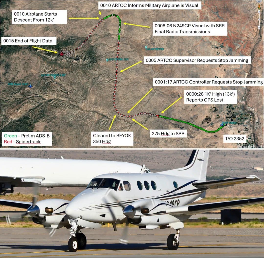
Shortly after departure, the crew contacted Albuquerque Air Route Traffic Control Center and received clearance to Sierra Blanca Regional Airport at an assigned altitude of 12,000 feet. Everything appeared normal until controllers noticed the aircraft climbing to approximately 13,000 feet, 1,000 feet above its assigned altitude. When questioned, the pilot reported that the aircraft had lost GPS capability and requested heading guidance from air traffic control.
This loss of navigation capability quickly became a critical issue. At the time of the flight, the U.S. military was conducting scheduled GPS jamming exercises covering a vast area of New Mexico. The flight crew had been provided with a Notice to Airmen (NOTAM) before departure warning that GPS, WAAS, GBAS, and ADS-B services might become unavailable throughout the region during the exact time window of the flight. Investigators later confirmed that the warning had been included in the ForeFlight briefing package received by the crew.
As the GPS outage continued, controllers attempted to help the pilots navigate toward Ruidoso using radar vectors. The crew initially planned to fly the RNAV approach to Runway 24 but later switched to requesting the ILS approach because GPS navigation was unavailable. During this period, air traffic controllers were also dealing with several other aircraft experiencing GPS interference. One aircraft reportedly had significant difficulty identifying ground-based navigation aids and required additional assistance.
Recognizing the seriousness of the situation, the controller contacted a supervisor, who in turn requested that the military suspend the jamming operation. Shortly afterward, ADS-B tracking quality improved, suggesting that navigation and surveillance systems were beginning to recover.
At approximately 12:08 a.m., while still more than 30 miles northeast of Sierra Blanca Regional Airport, the crew radioed that they had the airport area in sight and could continue visually. Air traffic control subsequently cleared the flight for a visual approach. The pilots acknowledged the clearance and stated they would cancel IFR in a few minutes. Those would be the final transmissions received from the aircraft.
After turning southwest toward the airport, the King Air began descending through the darkness. Between the aircraft and the airport stood the Capitan Mountains, with peaks reaching over 10,200 feet. Flight tracking data showed the airplane descending to approximately 9,400 feet before the crew initiated a climb. The climb came too late. The aircraft struck terrain at an elevation of about 9,950 feet, just below a mountain summit and only a few hundred feet from a radio facility located on top of the ridge. The final recorded data point showed the aircraft traveling at approximately 150 knots.
The impact destroyed the airplane and ignited a post-crash fire that quickly spread into a forest fire in the surrounding mountains. Emergency responders faced significant challenges reaching the remote crash site because of steep terrain and active fire conditions. All four occupants died instantly. The victims were later identified as pilots Keelan Clark and Ali Kawsara, along with flight nurses Sarah Clark and Jamie Novick.
Investigators discovered several factors that may have contributed to the accident. One of the most significant was the GPS jamming activity, which deprived the crew of their primary navigation source during a critical phase of flight. Another important factor was the lack of weather information at Sierra Blanca Regional Airport. The airport’s Automated Weather Observation System was out of service, and no METAR or TAF weather reports were available. Additionally, both published approaches for Runway 24 contained a note stating that the procedures were not authorized when a local altimeter setting could not be obtained.
The investigation also highlighted the challenges of operating in mountainous terrain at night. Although weather conditions were technically visual meteorological conditions, the combination of darkness, high terrain, and degraded navigation capability created an environment where pilots could easily lose situational awareness. Flight path data suggests the aircraft descended below the surrounding terrain before the crew recognized the danger and attempted to climb. The final climb indicates that the pilots likely saw the mountain or received some warning moments before impact, but there was insufficient time and altitude to escape.
The preliminary NTSB report has not identified a definitive cause, and investigators continue examining aircraft systems, pilot actions, air traffic control communications, navigation disruptions, and the role of military GPS interference. The wreckage was heavily damaged by impact and fire, making the investigation more complex. Experts have noted that the accident bears the characteristics of a classic Controlled Flight Into Terrain (CFIT) event, where an airworthy aircraft inadvertently flies into terrain because the crew is unaware of its proximity to obstacles.
The tragedy sparked renewed discussion within the aviation community regarding military GPS jamming operations, the vulnerability of modern aircraft to navigation disruptions, and the unique risks faced by air ambulance crews operating at night in mountainous regions. As the investigation continues, the crash of N249CP stands as a sobering reminder that even experienced crews flying a well-equipped aircraft can find themselves overwhelmed when multiple risk factors converge at the same time.